


Topic outline
-
Welcome to the "How to Create A Creative Map" class. Before diving into the exciting learning journey, we would like to get to know you better. This is a great opportunity to connect and build a sense of community within our class. So, please take a moment to introduce yourself with a brief video message. Share key details, such as your name, where you're from, and interesting facts about yourself. Welcome again, and let's make this a memorable and enriching experiece for all!
-
About this Course:
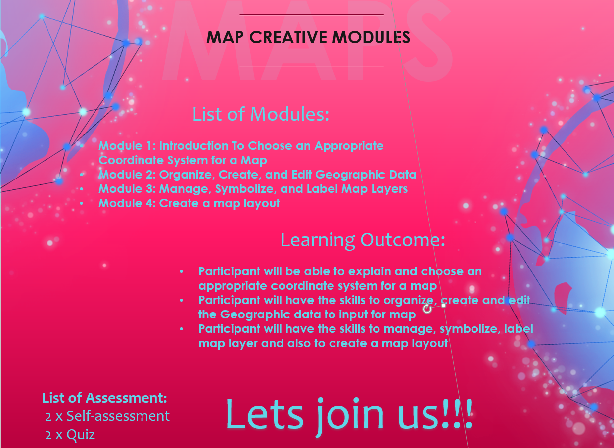
This micro-credential course teaches participants to produce creative maps without neglecting cartographic concepts in map-making using Qgis
-
Welcome!
This forum, created by and for map makers and students, is where every aspect of cartography can be admired, examined, learned, and discussed. All are welcome to join and participate in the quest for cartographic skills and knowledge.
-

-
-
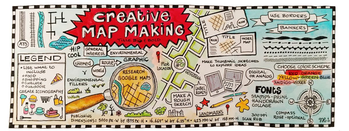
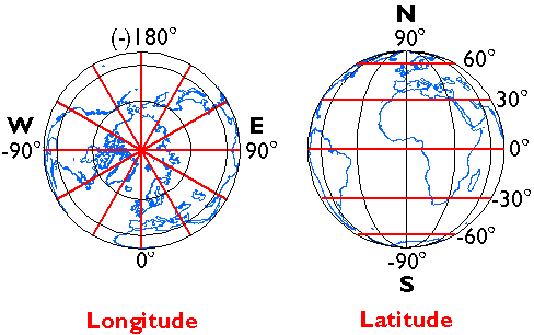
Learn some tips for choosing an appropriate projected coordinate system for your map!
-
Let's do it together!
Watch this video: Base Map and Georeferencing
-
-
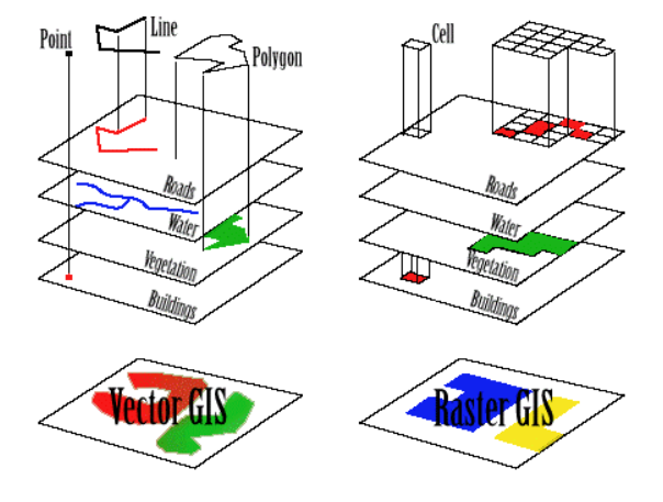
You can style and display points, lines, and polygons in a map or scene by defining symbols for features! To style features in a feature layer, you define symbols and apply them with a renderer. Styling points, lines, and polygons is also known as styling features because every feature contains a geometry and is styled with a symbol.
-
Let's do it together!
Please watch this video: Creating Point, Line, & Polygon by Digitizing
-
-
Managing, symbolizing, and labeling map layers is fundamental to cartography and geographic information systems (GIS). Properly organizing and presenting map layers can enhance your maps' clarity and communicative power.
-
-
AssignmentOpened: Thursday, 26 October 2023, 12:00 AMDue: Thursday, 2 November 2023, 12:00 AM
-
Quiz
-
Enhance your map with decorative borders, compass roses, and other embellishments that suit your theme
-
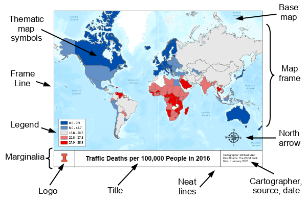
You need to make a layout to share your work as a printed map, poster, or PDF file. A layout is a composition of one or more maps, along with supporting elements such as a title, a legend, and descriptive text. Some layouts include more than one map. For example, a layout may have a main map and an overview map to show the main map in a larger geographic context.
-
AssignmentOpened: Thursday, 26 October 2023, 12:00 AMDue: Thursday, 2 November 2023, 12:00 AM
Digital mapping (also called digital cartography) is the process of data collection being compiled and formatted into a virtual image. The primary function of this technology is to produce maps that give accurate representations of a particular area, detailing major road arteries and other points of interest.
Digital cartography involves a few techniques and steps in the preparation of maps. Based on Figure 1, please elaborate on the descriptions and examples of each method for how the following maps are produced.

-
Quiz
-
Let's do it together!
Video 1: Create Map Layout
-
Let's do it together!
Video 2: Creative Map Layout
-
-
-
Summary
A map is a graphic diagram that provides information about the existence, location and distance between objects on the Earth's surface. A good map must have colors, symbols and labels to indicate the properties that exist on the surface of the earth. Therefore, in order for maps to provide information to humans, the process of producing maps must be produced with a high degree of creativity. The Micro-Credential program for the title Creative Map Production can be studied online through the modules provided. The modules provided contain several video tutorials, enote, self-training, online quizzes designed to help students study the course in detail and also learn basic theories related to mapping. This indirectly allows students to learn independently to produce creative maps. Students also gain exposure and knowledge of the basic theory of map production. Besides, students also gain the skills to create creative maps digitally using open software through QGIS software. Overall, the Micro-Credential developed for this creative mapping course is very useful to students to learn as a value added to students of their course to students taking the Geomatics Diploma program at Polytechnic Malaysia.
References:Robinson, Sale, Morriso and Muehrcke (1987). Element of Cartography Fifth Edition. Published by John Wiley & sons
Additional reference supporting the course
Dent, Torguson and Hodler. (2009). Cartography: Thematic Map Design 6th Edition. McGraw-Hill, New York
Mohd Paris Dziauddin & Ruslan Rainis. (2003). Pengenalan Kepada Kartografi. Prentice Hall, Pearson M'sia Sdn Bhd
McMaster & Shea (1992). Generalization in Digital Cartography. Washington, D.C. Association of American Geographers
Cromby. (1992), Digital Cartography. Englewood Cliffs, N.J Prentice Hall
Anson & Ormelling (1996). Basic Cartography for Students and Technicians, International Cartography Association, Technology and Engineering
Acknowledgement:
-
-
-
Feedback
-
